Ready To Hike The Michigan Shore To Shore Trail?
Don't Go Without These
Maps For Hikers, Made By Hikers!
15
Individual Map Panels
6
Michigan Counties Covered
232
Trail Miles
An incredible hiking experience made even better

Shore To Shore Trail Maps

Only $29.95
Special - $26.95
A Closer Look...
Check out these details:
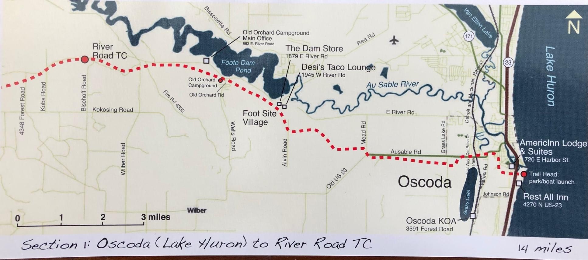
Fifteen individual 4'' x 8" map panels and an overview map cover 233.1 miles of the east/west Michigan Shore to Shore Trail. No need to haul bulky county atlases or paper maps.
The maps are printed on heavy duty 14 lb. water resistant stock so they will stand up to the rigors of hiking.
Map details on the front side include major roads, lakes, rivers, towns, campgrounds, horse camps, watering stops, and other landmarks so you have the information to make intelligent choices for your hike.
The backside of each panel is a detailed narrative of the trail section with information about resupply points, camping alternatives, warnings, trail descriptions and other important information to make it easy to navigate the STS.
An optional dual use lanyard and waterproof pouch provide even more protection from the elements and easy access on the trail.
Know Where To Go When
"Two Paths Diverge..."
Avoid taking wrong turns and having to back track over miles of already hiked trail because of not knowing where the trail goes. Trail markers are great and the Shore To Shore is well marked, but there are numerous opportunities to make a wrong turn and even the best hikers can miss a marker here and there. Having a well displayed trail map of the day's hike will give you peace of mind on the trail.


5 Reasons To Buy These Maps
01
Lightweight & compact
Each map set is only 4" x 8"and weighs ounces. Carrying this set is easy. Access 1 map per day instead of dealing with large foldable paper maps that blow in the wind, get soggy and tear in the rain or drizzle.
The optional waterproof travel pouch allows an individual map panel or the entire set of 15 maps to be carried around your neck removing the hassle of stopping to get maps out of a pocket or rummaging in through your packpack.
02
All the trail info you need about the STS
1 day hike per map panel allows you to access all the important information about the trail including hiking distances, water stops, camps, landmarks, crossroads, etc.
03
Durable, waterproof
14lb water resistant stock holds up under rough trail conditions. The optional dual use lanyard & waterproof travel pouch adds another layer of protection and provides reliable storage so the maps can be easily stored when not in use.
04
Easy to use & understand
Simple illustrations make navigating the trail easy and quick. County road maps, atlases and other non-hiking navigation resources are confusing and filled with information that isn't relevant for hikers. The maps are quicker and easier to use than online resources and...they don't require batteries!
05
Economical
Shore To Shore Trail Maps are a great choice when compared to the alternatives available like county & state atlases, recreational maps, and others. One set, one purchase and done. No more trying to find map resources you won't use.
Dual Use Lanyard & Waterproof Travel Pouch
Dual use lanyard easily clips to maps pouch and allows access to your trail maps without having to dig through your pack, pockets or storage. The lanyard unclips from the maps pouch and can be used as an adjustable lanyard for sunglasses.
Plastic travel & storage pouch gives you the ability to easily see a map while walking and keeps your maps safe from wind, rain and other elements.

Handy Add-On
Keep your maps safe from the elements and easily accessible while you hike and store them together so you don't lose any.

5.0 out of 5.0 stars
Michigan Shore To Shore Trail Maps are
maps for hikers, made by hikers and
appreciated by those who use them!

"This set of maps is the best if you're going to hike the Shore to Shore Trail. Lots of information, easy to read and way better than lugging folding maps or a county atlas.
I like the one-day/one-map organization."
Dan Pricopio, Avid hiker, business owner

Hi, I'm Will
Author, Librarian, Publisher
I created this set of trail maps for the Michigan Shore To Shore Trail after my own experience preparing for and hiking the STS.
I purchased multiple county & state atlases, road maps, recreational maps, Shore To Shore horseback trail maps and other geographical resources. They just weren't practical for taking on the trail.
So, I hired a graphic designer, researched the trail, met and talked with others who hiked or rode the Shore To Shore Trail and produced a set of maps that I think you will love.
See you on the trail. Hike on!
Will
